Hiking along the Zillertal Alps


View all 5 images
Description
The Zillertal Alps invite you to discover the majestic peaks, the crystal-clear lakes and the deep valleys. On views between 1800 and 2500 meters above sea level, you are steadily wandering south on the border of South Tyrol. Unique panoramas reward for partly sophisticated stages.
Please note that the execution of the tour is weather-dependent.
Accommodation: You wil be accommodated in 3 * inns/ hotels in cozy equipped rooms with bath or shower / WC, TV and majority internet / Wi-Fi. 3 x Together on cabins in shared rooms with bunk beds or mattress bearings and communal shower showers / WC. Sleeping bag, pillowcase and towel are to bring in the huts themselves. Due to their location, not all huts can offer flowing water, hot water or showers. Partly no water flush is available on the toilets. Payable on site: local tax.
Price per person:
1.7.-19.9.2024: EUR 625,-
Code: TIFKZI1 DM H
Tour
Day 1:
Individual arrival in Finkenberg.
Handing over the travel documents at the hotel. Overnight in a 3* hotel on site.
Day 2:
You start today's tour by crossing the Devil's Bridge. After the path leads steadily uphill, you will cross forests to get to the first viewpoint, the Larynx, at 1577m above sea level. After a well-deserved rest with a beautiful view of the Tux Alps, we continue uphill. The last part of today's path takes you through the Ebenschlag natural forest reserve before you reach the Gamshütte at 1921m
Overnight stay in the Gamshütte.
approx. 6 km, approx. 4 hours, altitude gain/descent: 1030 m / 10 m
Day 3:
Today takes you on the Berliner Höhenweg over steep grassy slopes to the so-called Grauen Platte. After a short descent you hike between mountain pines towards the Pitzenalm. Surrounded by several 3000m peaks such as the Zsigmondyspitze or the Ochsner, the path continues via Almen to the Wesendlkarsee. Just a short distance and you will reach the Friesenberghaus at 2498m, the highest hut on the tour.
Overnight stay in the Friesenberghaus.
approx. 14 km, approx. 7 hours, difference in altitude ascent/descent: 1100m / 550 m
Day 4:
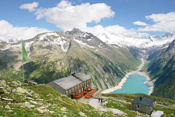
After the long stage yesterday, today's route offers a little more relaxation. The path first leads you to the Peterköpfl, this small sub-summit invites you to add another Steinmandl to the many already existing ones. Steinmandl are layered stones that stand out from their surroundings like a snowman. In the past, the paths in the rough high mountains were marked with them, today they serve as unique photo motifs and offer the opportunity to immortalize yourself on the summit. The path takes you further to the Friesenbergscharte. Finally, follow the signs on the Berliner Höhenweg to the Olpererhütte. This hut is enthroned majestically above the Schlegeis reservoir lake and, with a short suspension bridge, offers the ideal opportunity for a perfect souvenir photo.
approx. 6 km, approx. 3-4 hours, difference in altitude ascent/descent: 350 m / 450 m
Day 5:
Today you hike along the "Neumarkterweg" 502, newly laid out in 2007, into the Unterschrammacherkar. To 2 small mountain lakes and over a bridge that leads over the Unterschrammbach, change to path 535 in the direction of Schlegeisstaussee. Next to the mighty dam wall, which was built in 1973 with a height of up to 130m, you will come to a path that will take you to the foot of the dam wall. Now walk a little further parallel to the road to the Gasthof Breitlahner. From here you can take the public bus back to the starting point in Finkenberg.
Overnight stay in Finkenberg
approx. 13 km, approx. 5 hours, difference in altitude ascent/descent: 110m / 1260 m
Day 6:
Individual departure from Finkenberg.
Requirements and General Information
During the tour in the Zillertal Alps, you will mainly be in alpine terrain. Appropriate mountain equipment such as sturdy hiking shoes, clothing appropriate to the weather, rain protection and protection against the cold must be taken with you. As well as a backpack, sufficient drinking water, food, sun protection, a first aid kit, orientation aids, maps and a telephone. Also find out about the current weather situation and, if necessary, use alternative routes to reach your next accommodation.
The trails are signposted and marked, stay on the trails. Snow may still be present in early summer. The walking times are between 4 and 9 hours, it can go steeply uphill and also steeply downhill. Somewhat exposed. Accompaniment by an experienced hiking guide on request!
Included services
- 5 x nights with half board (2 x in the 3 * Inn/ Hotel, 3 x in the hut)
- 1 x ride by bus from the Schlegeisspeicher to Finkenberg
- 1 x hiking map 1 x per room
- daily service hotline from 9am - 7pm - also on weekends
 +43 1 58804 - 9992
 +49 211 616 818 0